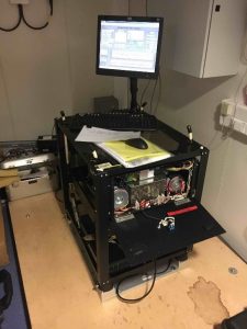
Anyone who has done a gravity survey on land knows that this can be a labour of patience – a bit of wind or uneven terrain makes things difficult. So, even though gravimeters have been used on ships and planes routinely since the 60s, I am still impressed with this technology. The RRS Discovery is equipped with a Micro-g LaCoste Air-Sea gravity meter, which is essentially a LaCoste-Romberg instrument on a gimbaled platform.
 Gravimeters were first used at sea in submarines in the 1950s and were modified for planes in the late 1950s. Most early applications were by the U.S. Military, but exploration companies quickly bought into the technology. They are now routinely used on research vessels and planes. For example, the NERC Twin Otter that flies in the Antarctic is equipped with one.
The instrument has its own air-conditioned room in the center of the ship on the Main Deck (which contrary to its name is almost the lowest deck, just above the Tank Top level where the engines are). It is housed in a sensor bucket, which sits on a stabilised platform. The pitching and rolling of the ship is counteracted by two orthogonally-oriented torque motors that are controlled by fibre-optic gyroscopes. Oil shock absorbers and shock cords also help to damp movement.
Gravity meters or gravimeters measure the value of gravitational acceleration, g, which is nominally 9.81 m/s2. We are interested in variations in this value that are due to variations in the density of the Earth’s crust and mantle. For example, a magma chamber will be less dense than the surrounding rock. Gravimeters can measure very small changes in g; changes in elevation on the order of a few meters will affect a gravimeter reading. The unit we measure g in is a Gal – named after Galileo – which is 10-2 m/s2, and mGal anomalies are normal (10-5 m/s2), but a modern survey can detect even variations down to microGals (mGal).
Gravity corrections: Because the Earth can be approximated as an oblate spheroid (the shape of a flattened orange), g will be larger near the poles, because you are closer to the centre of the Earth, and less near the equator. Correcting for this is known as the latitude correction. To give you an idea of how important this is, the variation between the equator and poles is over 5000 mGal, and yet variations in gravity measured last year over the Chain Fracture Zone are only ±50 mGal. There is also a need to correct for variations in elevation and topography. On a mountain side, you are further away from the centre of the Earth, but the mass of the mountain, both above and below, will exert gravitational attraction on the instrument. With land data, these corrections and the latitude correction are used to calculate the well-known Bouguer anomaly. At sea we are on the Earth’s equipotential surface – sea level – so there is no elevation correction, but there is a need to correct for variations in water depth. Furthermore, gravity measurements will vary on a moving object, like a ship or plane, as the movement affects the gravitational force of attraction. Moving against the spin of the Earth increases gravitational attraction, and vice versa. The correction for this is named after the Hungarian scientist Eötvös, and is dependent on the speed of the ship, the direction of travel and the latitude. The latitude and Eötvös corrections combine to give what is known as the Free Air Anomaly, which is often what is reported with surveys over the sea. We will also be applying a Bouguer correction for variations in water depth. Another common correction on land or at sea accounts for the effects of tidal variations, but this affect will be small in the middle of the ocean.
 Finally, the instrument will drift a bit due to temperature variations, so repeat measurements are taken at a common spot or measurements are related to an absolute gravity reading at a known spot (these are known as tie points). In our case the tie point is on Tenerife.
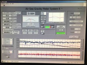
To the left is the display output for the gravimeter on the Discovery.