We are now firmly in the tropics and making good time to the first site. The wind is at our backs and the sea is still calm. The biggest issue has been problems with our satellite links, which has led to a lack of internet and inability to receive our email and the like.
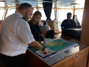 One of the most expensive items with a ship is fuel, so minimising distance travelled is an important consideration. However, another reason to pick the most efficient route is to maximise the science that can be done. A final consideration is that we need to be back in port for a set date. Hence, there is a lot of discussion about routes and, in our case, the best schedule to pick up the instruments, without spending too much time in the pirate infested waters of the Gulf of Guinea (bit of an exaggeration). Here, Kate and Sai discuss routes on the bridge with Colin, the second officer (mate).
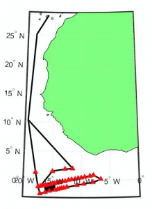 The route we have chosen is shown to the left. We are hugging the coast of Africa in transit to our first station, which is the most northeasterly station. To give you a sense of time, it will take 5.5 days of sailing to get to the first site. An ocean bottom seismometer and magnetotelluric instrument have been deployed at each site (marked by a red triangle). Cutting the diagonal path just above the 15oW, rather than sailing west across the top 4 stations, will save us 12 hours.
Saving time will enable us to survey the Chain Fracture zone. In comparison to the much larger Romanche Fracture
Zone, relativel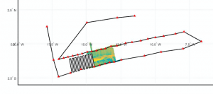 y little is known about the Chain. The deployment cruise on the Langseth mapped part of the FZ using side-scan sonar and swath bathymetry. We are hoping to have enough time to finish the mapping. The proposed swath lines over the Chain FZ are shown, right.